Conference review
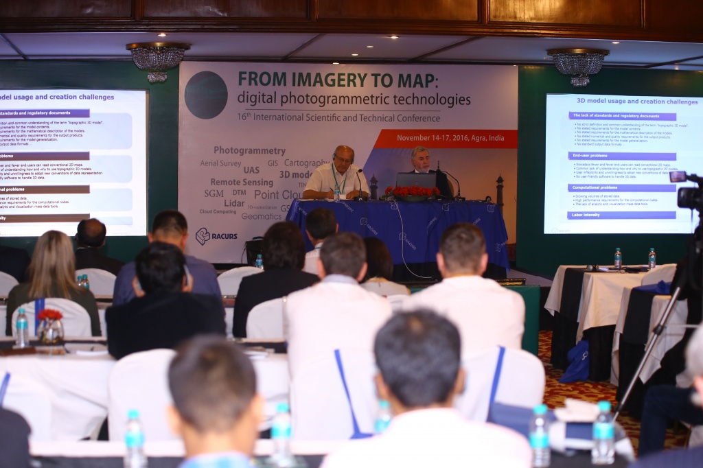
This year the annual conference “From imagery to map: digital photogrammetric technologies” was held for the 16th time. Each year its geography covers new countries.
The following companies supported this year’s conference as sponsors:
 Silver sponsors – DigitalGlobe (USA), Imaging Services (Korea), National Company “Kazakhstan Gharysh Sapary” (Kazakhstan).
Scientific support was provided by:
· ISPRS - International Society for Photogrammetry and Remote Sensing
· State Space Corporation ROSCOSMOS
· Russian GIS-Association
· The Russian Society of Geodesy, Cartography and Land Management
This year the conference brought together 60 specialists representing 36 organizations from 7 countries.
Scientific program of the 16th conference included 25 reports delivered by representatives of India, Israel, The Netherlands, Korea, Russia, Switzerland and USA.
Day one
Section “Common Geomatic Problems”. Conference was started by Durk Haarsma (GIM International, The Netherlands). He presented report “Geomatics professionals: reaching out to the outside world!” Mr. Haarsma raised important questions about significance of the field and creation of the easy way of communication between professionals and users. New approach to the space modeling was proposed by Armin Gruen (Professor Emeritus, ETH Zuerich, Switzerland). Moorea Avatar is not only a fantastic island, but also an international project to create a model of the space-time dynamic of the processes, occurring both at sea and on land.
Section “Aerial and UAV Survey” joined together suppliers and users of solutions of manned and UAV aviation. Yuri Raizman (VP EMEA & Chief Scientist, VisionMap, Israel) spoke about cartography system A3 Edge and news of the VisionMap company. Applied significance of UAS data processing was developed by Natalia Vorobyova (Head of Department, Finko, Russia); UAS data processing retrospective was presented by Alexey Smirnov (Technical SupportManager, Racurs, Russia).
Section “3D modelling” became interesting. Victor Adrov (Managing Director, Racurs, Russia) opened this section with review of Photogrammetric methods of 3D modeling. Indian colleagues shared their experience: Anurag Ohri (Associate Professor, Department of Civil Engineering, Indian Institute of Technology (Banaras Hindu University)) reported about 3D Modeling of the Vishwanath Temple, Varanasi, using close RangeDigital Photogrammetry. Himanshu Nagrath (Co-founder, Indshine Geoinformatics, India) presented experience of 3D Modelling of IIT BHU Varanasi campus, using photogrammetric techniques on UAV captured data. Aleksandr Voitenko (Head of Department, Kadasrtsurvey, Russia) demonstrated results of Lidar point cloud vs dense DSM.
In DPW PHOTOMOD & practice experience section the following reports were presented: Vladimir Arkhipov (Development Director, Lesproekt, Russia) spoke about technological innovation in PHOTOMOD stereo taxation, Victor Adrov (Managing Director, Racurs, Russia) delivered a speech devoted to experience of tests of PHOTOMOD work in cloud services. Dmitry Kochergin (Head of Technical Support Department, Racurs, Russia) presented new functionality of PHOTOMOD 6.2 and perspectives of PHOTOMOD in India were specified by Balen Basu (Director, OPSIS System, India).
 Day two
Traditionally, the start of the second day of the conference has been dedicated to Earth survey from space. Section “Current RSD constellation” brought together representatives of Russia, India, USA and Korea. Valery Zaichko (Head of Department, State Space Corporation ROSCOSMOS, Russia), Ilia Yudin (Sales Manager, DigitalGlobe, USA), Wook-Hyun Choi (Vice President, SI Imaging Services, Korea), Krishanu Acharya (Senior Manager, Stratagic Sales, SkyMap Global, India) presented possibilities of their national remote sensing . Aleksandr Fedoseev (Head of Sector, Space Rocket Centre “Progress”, Russia), Aleksandr Chekurin (Sales & Marketing Director, Racurs, Russia) and Victor Nekrasov (Head of Laboratory, VNIIEM Corporation, Russia) shared practical experience of remote sensing using.
Besides data receiving, processing is very important. Questions of end product, developed on the base of space data, were considered in section “New technologies of RSD processing”. This section was opened by Oleg Gomozov (Head of scientic-production complex, Research Institute of Precision Instruments, Russia) presenting scale project “Foundation of Remote Sensing Thematic Data Processing Center on the Russian Technologies Basis”. Viacheslav Butin (Director Business Development, Sovzond Company, Russia) and Viacheslav Lobzenev (CEO, Innovative centre, Russia) presented service and program solutions. Sergey Kadnichanskii (Head of Department of photogrammetry and RSD, Center of Geodesy, Cartography and SDI, Russia) closed this section with the report dedicated to evaluation of contrast of digital aerial and space images.
Day three
Master classes and roundtables. During the roundtable “From UAS to satellite: optimal image acquisition strategies” advantages and disadvantages of each method of data receiving: survey from UAV, manned vehicles and space systems were discussed. Perspectives of development of each survey method were considered. Ideas on conventionality of such classification were advanced, for example, Professor Armin Gruen (ETH Zurich, Switzerland) noticed that there were UAVs with capability of carrying and flight characteristics equal to manned vehicles, able to carry professional large-scale aerial survey cameras and precision nautical equipment.
The criteria for choice of survey types depending on parameters of specific project were discussed. The right to existence of all the ways to get survey and necessity to incorporate features of specific project for the correct choice of basic data were recognized unanimously.
The second roundtable “New ways of photogrammetry” was debating. Professor Armin Gruen set a vector of discussion, making analysis of present stage of technological development of society (“we live in the world of version 4”). Participants of the roundtable were offered to discuss the following 5 themes:
- Automation of basic operations (АТ , DTM, orthotransformation). What next?
- Integration of various sensors, nadir and inclined survey. Problems and suggestions.
- Creation of 3D surface and models. Where to go? Problems and solutions.
- Universality or specialized solutions (input data, final results)?
- Photogrammetry in clouds. Desctop, SaaS, IaaS
These themes were in demand among the participants actively participated in discussions. It was found out that different countries have much in common both in problems and in the ways to solve them. As a result of discussions, interesting ideas of creation of mutual Russian- Indian companies that allow receiving synergy effect from combination of partners’ strong sizes, started up. It could be said with the confidence that this roundtable was very useful.
Media support of the conference’ carrying out was provided by specialized Indian mass media - Geospatial Media&Communications, that made some interviews with Russian state and private companies – participants of the conference. This for sure will help to strength Russian-Indian business relations in the field of geospatial technologies.
Indian style Gala dinner became the bright final of the passed conference. In traditional PHOTOMOD lottery fortune favored OPSIS System (India) and “Geoinformation” (Kemerovo, Russia).
Traditionally, many participants asked a question concerning the next conference: when and where will the 17th conference take place. We decided not to dally off the decision and we are glad to announce that next year the conference will be held in Israel at the end of October.
We thank all our colleagues, friends and partners for participation and we are looking forward to seeing you again next year!